|
|
| Your complete Guide to the North Rim of the Grand Canyon in Arizona. This guide also includes information on Lodging, Camping, Guided Tours, Maps and Vacation Retreats in the Southern Utah and Arizona area. This site is packed with information and photos of the Grand Canyon and the surronding areas of interest. |
|
|
|

|
Checkerboard Mesa The most famous landmark in Zion due to its unique crossbedding
|
|
Entering Zion Park from the East side, one of the first sites to catch the eye is the Checkerboard Mesa, the most famous landmark in Zion National Park. It’s geology is unique due to the cross-bedding. It showcases the rock formation that has eroded over millions of years in rare sections of Navajo Sandstone.
The horizontal furrows were cut during the Jurassic period by blown sands of the huge ancient sand dunes that once stood in place of the Monoliths you see today. The vertical slits were formed much later after brittle rock had formed.
|
| The formations of Zion are still changing today, slowly over time the great monoliths you see will return to the Great Sand Dunes from where they were born in ancient days. The forces of Nature will force their way through layers of sedimentary rock every day of our future, just as they have in our past. The largest monolith in the world, the great white throne will be reduced to layers of sand. |
|

|
The East section of Zion Park is known as "slick rock country.” Here the rocks are a mixture of white and varied tints of brown or orange, due to the minimal presence of iron-oxide that the other layers of sandstone posses in greater amounts.
The slickrock section of Zion showcases the powerful effects of erosion over a great period of time. The geology of Zion transforms dramatically as one travels from the east section of the park through Zion's long tunnel.
The 1.1 mile long tunnel was blasted and cut in the thick Navajo sandstone during early 1900. Imagine cutting through 2,000 foot thick sandstone with the machinery available in the early 1900’s. In those days the whole process was considered a technological wonder.
|
| My Grandmother lived here during the time the tunnel was cut and tells vivid stories of the process. Zion National Park was the first area to be named a National Park in Utah and as such is the oldest of the Parks. The scenic drive through the tunnel to the east section of the park is often said to be the most magnificent. |
|

|
1.1 mile long Zion tunnel
|
|
To the right is the view from the Canyon Overlook trailhead of the1.1 mile long Zion-Mt.Carmel tunnel, one of two tunnels in Zion Park. This trail is an easy 1 mile hike that leads the hiker through hoodoos and a rock alcove with moist hanging gardens. The trail ends in a nest of Hoodoos high above the canyon floor. Looking down over the fenced edge you see the stunning view of the Canyon floor from high above with sandstone cliffs rising in every direction.
|
| If you are driving through the park, think about taking the time to hike this short trail. The view from the point is the most incredible in Zion Park. After leaving the tunnel there is a rapid drop to the bottom of the canyon floor as you enter the area of the Kayenta Formations and the towering Navajo. |
|
|
Beehives - Scenic Byway 9
|
|
Note the great Beehives, (photo left) a show of turrets carved into the very top of the Navajo sandstone. As you travel down the six switchbacks, look for the Great Arch (photo below) carved into the mountain side by nature. The geology of the arched structure was caused from jointing.
|
|
Zion Park is a small park, measuring only 147,000 acres, but the diversity of plants, animals, rock formations is amazing. Like Zion’s other features, the park hosts a wide variety of hikes, from a short jaunt to difficult over night backpacking
|
|

| The Great Arch by Zion Tunnel |
|
Park at the junction of Scenic Byway 9 and the turn off to Zion Canyon. A short shuttle ride will take you to the end of the Canyon. Zion Canyon was carved over time by the steady flow of water from the Virgin River, a process that continues even today. The river seems mild, but it is still capable of transporting tons of debris down its stream. At the end of the road is the Temple of Sinewava, this is where the trail head to the Zion Narrows is located.
|
|


|
The Narrows trail is the most famous slot canyon in the US. The hike begins easy with a smooth graded dirt trail, passing swamps and the Zion snail. This is the only place in the world this tiny creature can be found. The Gateway to the Narrows trail ends and the hikers are persuaded to climb into the Virgin River and hike their way up stream until the canyon walls close in tight on both sides of them.
The photos left show a small sample of the patterns found in Zion,
Hoodoos! They seem to be everywhere in the parks of Southern Utah. At the bottom of the page photos show the rather uniform Hoodoos of Bryce Canyon and Cedar Breaks National Monument. Even the Grand Canyon has its Hoodoos. You can see one lone Hoodoo standing tall in the center of the Canyon.
|
| I have always liked this hoodoo (photo right) found along Scenic Byway 9 in Zion Park. |
 |
The same tough little tree has been peeking its head from the top of this unique rock formation since my Grandmother was a child. The hoodoo is located near Canyon Jct. and Scenic Byway 9. This is just one of many examples of how life survives in the harsh desert of the west. |
|

|
An isolated Hoodoo in Bryce Canyon located along the Mosey Cave trail
|
|
The Geology in Bryce Canyon National Park - The hoodoos in Bryce literally crowd together to form the magnificent views. The hoodoo formations are crowded next to each other making up the twenty mile long series of amphitheaters of Bryce Canyon. The hoodoos of Bryce are sculpted Claron rock formations. Claron is a colorful combination of pinks and oranges caused by trace amounts of iron oxide, the white formations you see in the park are lacking the iron oxide. The patterns of Bryce’s rock formations show off their unique crisscross design formed though a long process of freezing and thawing.
The process still continues today, as the rock formations continue to be designed by nature. Water weeps into fractures at the rocks surface turning to ice as temperatures drop, then the ice expands pushing the fractures open. The overnight freezing and daytime thaw are abundant, occurring 2-3 hundred times a year.
|
|
Comparing the Claron of Cedar Breaks and Bryce Canyon shows that that of Cedar Breaks is thicker and more colorful. This is a smaller amphitheater, but certainly worth the visit. Cedar Breaks is located off Hwy 14.
Turning off ten miles past Mt. Carmel Jct. takes you to one of the few entrances of the Grand Staircase National Monument. Follow the Bench road located in the tiny town of Glendale into the Monument. Stay on this graded dirt road for fifteen miles and you come to a turnoff that leads to the Lick Wash trail. This is a wonderful and secluded slot canyon. Return to Mt. Carmel Jct. and head towards Kanab to reach the North Rim of the Grand Canyon.
|
|

|
The drive from Mt.Carmel Jct. to the North Rim of the Grand Canyon is beautiful. From Mt. Carmel Junction (the Jct. to Zion, Bryce and Grand Canyon) to Kanab the light and dark stained Vermillion Cliffs are eye catching with a beauty of their own much different of that from any of the parks in Southern Utah. Traveling down Scenic Byway 89A on the way to the Grand Canyon leads you through the Kaibab Forest. Here from a distance the five stairsteps of the Grand Staircase National Monument are evident, no wonder the name Grand Staircase.
|
|
The Monument is huge, consisting of two-million acres of plateaus, mesas, buttes, slot canyons all in a primative setting. This staircase extends 150 miles from bottom to top and rises 3500 feet in elevation. The old bottom step is seen in the photo above, it is the North Rim of the Grand Canyon and stretching past all other steps to the young section of Bryce Canyon. Each of the main risers in the staircase are named for their colors: Pink, White, Grey, Vermillion and Chocolate.
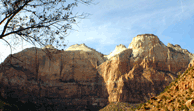
The Geology of the Grand Canyon - Located near Zion National Park (less than 2 hour drive from Zion) is the North Rim of the Grand Canyon. This section of the Canyon is said to be more spectacular than the crowded south side. The view of the North Rim, (photo left) is exilerating. The North Rim is 1,000 feet higher (9,000 feet) than the south, leading to cooler temperatures and a different environment.
The Canyon is two billion years in the making, over a mile deep and almost three-hundred miles long, the Grand Canyon is a geologic wonder. Over vast amounts of time mountains were built, eroded away and sediment set down in unparalleled configurations and forms, shifting, uplifting - forming the Grand Canyon. Millions of years ago water flowed through the mountains, starting as just a stream, the Colorado River carved its way through the many layers of soft rock. The erosion continued until the stream of water became the Colorado River
|
|
The force of the water drilled through the Kaibab Limestone to the Coconio Sandstone and Hermit Shale, and on through the other layers until, finally – the oldest rocks existing were uncovered. This wonder located in Arizona is a must to see. Mt. Carmel Jct., the junction to Zion National Park, Bryce Canyon, Cedar Breaks, Grand Staircase Monument and the Grand Canyon offers you a location from which you can visit all the wonders of Color Country.
|
|
|
Scenic Byway 9 through Zion Park to Mt. Carmel Jct. is open year round.
|
 |

for more Info:
|
| |
This free scr
ipt provided
JavaScript Kit
Local Weather and Golf Information
Ingenious Solutions© Copyright 2003
|
|
|
|
