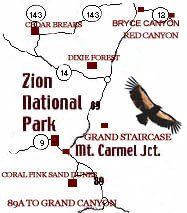
|
Scenic Byway 14 through Dixie National Forest:
Scenic Byway 14 from Cedar City to its junction at Scenic Byway 89 is one of the most traveled in the Southern Utah area. Dixie National Forest’s two million acres of forest, ponds, lakes and mountains stretch across Southern Utah.
Cross Country Sking and Snow Mobil Trails:
In the winter there are cross-country ski trails and snow mobile trails.
Autumn leaves along Scenic Byway 14:
long Scenic Byway 14 rows of crowded aspens create a spectacular view. Having the opportunity to drive this Scenic Byway in September as the green leaves transform to red and yellow is a treat.
Scenic Byway 148 to Cedar Breaks National Monument:
Turn off Scenic Byway 14 to Scenic Byway 148 to Cedar Breaks National Monument. Here is a three mile wide, two thousand foot deep amphitheater of elegant hoodoos. Cedar Breaks is less crowded than Bryce Canyon, sitting two thousand feet higher than Bryce Canyon is has cool summer weather. Once in the Monument there is a five mile Rim Drive with four view points to stop at. Due to snow Scenic Byway 148 to the Monument is closed in October and opens again each May.
Next: Dixie National Forest History
|